Trusted by Kenya's Infrastructure Agencies
Engineering surveys are different from cadastral surveys. While cadastral surveys establish legal boundaries, engineering surveys provide the precise positioning data needed for construction. Before building a road, bridge, or building, engineers need accurate ground elevations, existing feature locations, and reference points. This is where engineering survey comes in.
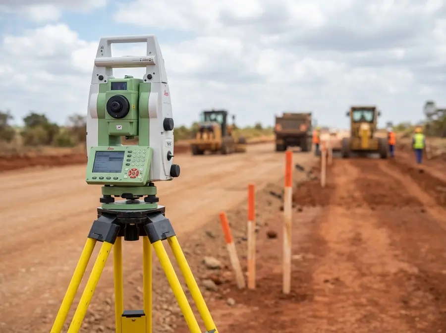
Our engineering surveys support construction projects from roads and bridges to buildings and utilities. With 30+ completed government infrastructure projects including KeRRA road contracts, long-term Kilifi County partnership, and NCA Category 6 and 7 certification, we deliver the precision and compliance required for successful infrastructure development. All surveys follow Kenya Road Design Manual 2025 standards.
Engineering Survey Services
Road Construction Surveys
KeRRA-compliant road surveys from preliminary design through final as-built. Centerline surveys, cross-sections, right-of-way marking, and drainage design support per Kenya Road Design Manual 2025
Construction Staking
Transfer design coordinates from plan to ground. We stake building corners, road alignment, pipe inverts, structural foundations, and any feature that needs precise positioning for construction
As-Built Surveys
Document what was actually built for project handover, contractor payment verification, and future reference. Compare constructed features to approved design drawings
Control Network Establishment
Establish permanent reference points tied to Kenya national geodetic network. Enables all project measurements to use consistent coordinates and elevations
Topographic Surveys for Design
Detailed ground surveys to support civil engineering design. Contours, spot levels, existing utilities, and feature mapping at scales from 1:200 to 1:2500
Structural Monitoring
Track movement of buildings, bridges, slopes, and retaining walls over time. Detect settlement, tilt, or displacement before it becomes a safety issue
Engineering Survey Process
Project Briefing
We review project drawings, specifications, and survey requirements with your engineering team. Understand the scope and establish deliverable formats
Control Network Setup
Establish or verify primary control points referenced to Kenya national grid. All subsequent measurements tie to these permanent markers
Field Survey Operations
RTK GNSS and total station surveys capture required data. Regular quality checks ensure accuracy meets project specifications
Data Processing & Deliverables
Survey data is processed, adjusted, and formatted for engineering software. Deliverables include DWG, DXF, LandXML, and PDF reports
Construction Support
Ongoing staking, verification, and as-built surveys throughout the construction phase. Available for site visits and design clarification
Standards and Compliance
Kenya Road Design Manual 2025
Official surveying methodology for all road construction projects in Kenya. Defines accuracy standards, cross-section requirements, and deliverable formats for KeRRA and KeNHA projects.
NCA Requirements
National Construction Authority specifications for survey accuracy and professional qualifications. We hold NCA Category 6 (roads and earthworks) and Category 7 (structural works) certification.
KeRRA Specifications
Kenya Rural Roads Authority technical requirements for survey control, centerline accuracy, and as-built documentation on rural and county road projects.
KeNHA Specifications
Kenya National Highways Authority standards for national trunk road surveys including high-accuracy requirements for interchange and bridge construction.
International Geodetic Standards
ISO 17123 instrument verification, GNSS processing following IGS standards, and adherence to international best practices for geodetic control networks.
Project Types We Survey
Road Construction
Centerline surveys, cross-sections every 20m to 50m intervals, drainage structures, culvert locations, right-of-way marking, and pavement thickness verification. Requirements: Horizontal accuracy 10mm, vertical accuracy 5mm per Kenya Road Design Manual 2025. Full compliance with KeRRA or KeNHA specifications depending on road classification.
Bridge and Culvert Construction
Foundation excavation surveys, pier and abutment positioning, deck level verification, bearing elevations, and approach road tie-ins. Requirements: Higher accuracy required for structural elements. Typically 5mm horizontal, 3mm vertical for bridge foundations and bearing surfaces.
Building Foundation Layout
Transfer architect drawings to ground with building corner stakes, column grid layout, foundation excavation depths, and floor level verification. Requirements: Accuracy depends on building type. Residential typically 20mm, commercial 10mm, industrial facilities requiring precision equipment may need 5mm or better.
Pipeline and Utility Corridors
Route surveys for water, sewer, oil, and gas pipelines. Includes centerline alignment, invert elevations for gravity flow, conflict detection with existing utilities, and valve chamber positioning. Requirements: Gravity sewer requires precise invert elevations (5mm vertical accuracy). Pressure pipelines more tolerant but still require accurate horizontal positioning for conflict avoidance.
Irrigation Scheme Surveys
Canal alignment, water offtake structures, drop structures for elevation changes, farm block layout, and drainage system surveys supporting agricultural development. Requirements: Accuracy depends on scheme type. Gravity-fed systems require 10mm vertical accuracy for proper water flow. Pumped systems more tolerant on elevation but require precise volume calculations.
Railway Alignment
Track centerline surveys, platform positioning, overhead electrification support locations, and railway bridge surveys requiring coordination with existing rail operations. Requirements: Railway construction demands high precision. Track centerline typically 5mm horizontal and vertical. Platforms must match existing station geometry where connecting to operational rail systems.
Technology & Standards
CORS-enabled RTK GNSS for centimeter-level positioning, robotic total stations for precision angle and distance measurement, digital levels for benchmarking. All surveys comply with Kenya Road Design Manual 2025, NCA standards, and international best practices. Deliverables compatible with AutoCAD Civil 3D, Bentley OpenRoads, and other civil engineering software.
Government and Institutional Experience
Kenya Rural Roads Authority (KeRRA)
Road construction surveys across multiple Kenyan counties including preliminary surveys, construction staking, cross-section surveys, drainage structure positioning, and final as-built documentation. Projects range from 5km to 50km road lengths covering both low-volume rural access roads and higher-classification county connector roads.
Kilifi County Government
Ongoing survey support for county infrastructure including road improvement projects, public building construction, water and sewer system extensions, and facility upgrade projects. Provides rapid response survey services for county development initiatives.
Various County Governments
Engineering surveys for county road projects, public facility construction, market infrastructure, and water projects across coastal and inland counties. All work complies with county procurement requirements and benefits from AGPO 30% preference for women-owned enterprises.
Common Questions About Engineering Surveys
What is construction staking? +
Construction staking transfers design coordinates from drawings to the physical ground. When an engineer designs a road or building, the design exists as coordinates and elevations on paper or in CAD software. Construction staking means a surveyor goes to the site with GPS and total station equipment and marks the exact locations where construction should occur. For a road, we stake the centerline alignment, edge of pavement, slope limits, and drainage structures. For a building, we stake corner points, column grids, and foundation limits. Contractors use these stakes as physical guides to position their equipment and materials correctly.
What is an as-built survey? +
An as-built survey documents what was actually constructed, as opposed to what was designed. Construction rarely matches design drawings perfectly. Ground conditions change, design modifications occur, and contractor execution varies slightly from plans. As-built surveys measure the final constructed positions and elevations of roads, buildings, pipelines, and other infrastructure. This documentation serves three purposes. First, it verifies the contractor built what was approved and supports payment certification. Second, it provides accurate records for future maintenance and repairs. Third, it creates a baseline for infrastructure asset management systems. For government projects, as-built surveys are typically required before final payment approval.
Why do I need control points on my construction site? +
Control points are permanent reference markers with known coordinates and elevations tied to the Kenya national geodetic network. They serve as the foundation for all project measurements. Without control points, different survey crews might use different coordinate systems, making it impossible to relate their measurements. Control points enable consistent positioning throughout the project lifecycle from initial design surveys through construction staking to final as-built documentation. They also allow construction to stop and restart without losing positional reference. For road projects, control points typically placed every 200m to 500m along the alignment. For building sites, minimum four control points surrounding the construction area. All our control points reference CORS stations providing connection to international geodetic standards.
What accuracy do you achieve? +
Accuracy depends on project requirements and survey method. For CORS-referenced RTK GNSS positioning, we routinely achieve 10mm horizontal and 15mm vertical accuracy. For total station measurements, precision work reaches 3mm to 5mm both horizontal and vertical. Road construction surveys following Kenya Road Design Manual 2025 require 10mm horizontal and 5mm vertical accuracy, which we consistently meet. Bridge foundations and structural elements often require higher accuracy, typically 5mm horizontal and 3mm vertical, achievable through careful total station work and network adjustments. Residential building layout is more tolerant, typically 20mm acceptable. We calibrate instruments regularly per ISO 17123 standards and perform independent checks to verify accuracy meets project specifications.
What are your deliverable formats? +
We provide survey deliverables in formats compatible with modern civil engineering software. CAD deliverables include DWG and DXF formats for AutoCAD Civil 3D. Three-dimensional alignment data provided as LandXML files compatible with Bentley OpenRoads, Trimble Business Center, and other design packages. Cross-section data formatted for direct import into road design software. Control network documentation includes coordinate lists, adjustment reports, and monument descriptions. As-built surveys delivered as marked-up design drawings showing deviations from plan. All projects include PDF reports with survey methodology, accuracy statements, and professional certification. For government projects, we follow agency-specific format requirements. Digital terrain models provided as TIN or gridded surfaces depending on client preference.
Do you work with government contracts? +
Yes, government infrastructure projects are a core part of our business. We have completed 30+ projects for Kenya Rural Roads Authority (KeRRA) and maintain long-term partnership with Kilifi County Government. Our firm holds NCA Category 6 and Category 7 certification required for government road and building contracts. We are registered with AGPO (Access to Government Procurement Opportunities) as a women-owned enterprise, qualifying for 30% preference in county and national government procurement. We understand government procurement procedures, comply with public project reporting requirements, and deliver survey documentation in formats required by KeRRA, KeNHA, county governments, and development partners. Our experience includes World Bank funded projects, African Development Bank projects, and county development fund initiatives.
Infrastructure Project Survey Needs?
Engineering survey fees typically 5-8% of total project value. For KES 100M-1B infrastructure projects, survey component ranges KES 5M-80M depending on scope, terrain complexity, and deliverables. Contact us for project-specific proposals.