Due Diligence Before Purchase
Land fraud is a serious problem in Kenya. Fake title deeds, double-selling of the same plot, boundary manipulation, and forged survey documents cost buyers millions of shillings every year. Before you pay for any land, you need independent verification by a licensed surveyor who is not connected to the seller.
Our boundary verification service checks that what you see on the ground matches what is recorded in the Land Registry. We verify the title deed is genuine, confirm the boundaries are correctly marked, and identify any encroachments or disputes. Essential for diaspora investors, first-time buyers, and anyone purchasing property in Kenya.
Our Verification Services
Pre-Purchase Verification
Comprehensive site inspection by ISK-registered surveyors. We verify boundaries match title deed, check for encroachments, and assess fraud risk before you sign
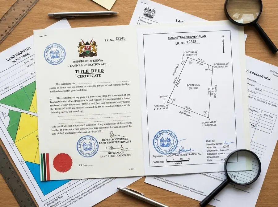
Registry Index Map (RIM) Verification
Confirm boundaries match government cadastral records. We compare physical beacons to Land Registry RIM, identify discrepancies, and verify parcel numbers
Title Deed Search & Document Review
Verify title authenticity with Land Registry, check for caveats or encumbrances, review ownership history, identify red flags
Fraud Risk Assessment
Professional assessment: GREEN (safe to proceed) or RED (danger, walk away). We identify warning signs of fake surveys, forged documents, and boundary manipulation
Beacon Certificate Issuance
Legally binding documentation of property corners. Admissible in court for dispute resolution and serves as permanent record of boundary positions
Dispute Resolution Support
Independent surveys to resolve boundary disagreements. We provide neutral third-party documentation, mediation support, and expert testimony if needed
Our Step-by-Step Verification Process
Initial Consultation
We meet with you to understand the property, review the title deed copy, discuss concerns, and outline verification scope. We collect all available documents including sale agreements, sketch maps, and previous surveys.
Land Registry Search
Our team conducts official searches at Ardhi House (Nairobi) or relevant county land registry. We verify title authenticity, check for caveats, encumbrances, or legal restrictions, and confirm registered owner matches the seller.
Registry Index Map Comparison
We obtain the official RIM from the Survey of Kenya archives. This government cadastral map shows the legal parcel boundaries, dimensions, and neighbors. We compare the RIM to the title deed and prepare for field verification.
Physical Site Inspection
ISK-registered surveyors visit the property with GNSS equipment. We locate boundary beacons, measure distances and angles, identify any encroachments or structures over boundaries, photograph all beacons and site features, and create detailed field notes.
Neighbor Consultation
We speak with adjacent property owners to identify boundary disputes, verify their understanding of boundaries, and check for conflicting claims. Neighbor interviews often reveal problems the seller will not disclose.
Verification Report
We compile all findings into a written report with GREEN (safe to proceed) or RED (do not buy) recommendation. The report includes title authenticity assessment, boundary accuracy analysis, identified risks and red flags, photographs and maps, and specific recommendations. You receive this before making any payment.
What We Actually Check
Title Deed Authenticity
We verify the title with the Land Registry, not just visually inspect a photocopy. We check the title number exists in official records, confirms registered owner, and ensures no forgery indicators.
Boundary Beacon Positions vs RIM
We compare physical boundary markers on the ground to the official Registry Index Map from Survey of Kenya. Discrepancies between RIM and beacons indicate either boundary fraud or survey errors that must be resolved.
Encroachments and Overlaps
We identify if any structures, fences, or cultivation cross into the property from neighbors, and equally important, if the property encroaches onto adjacent land. Encroachments create legal liability.
Caveats and Encumbrances
We search for legal restrictions on the property including caveats (legal warnings against transfer), mortgages or bank charges, court orders or disputes, and utility easements or rights of way.
Ownership Chain Verification
We trace the ownership history to verify the seller actually owns the land and that previous transfers were legitimate. Breaks in the ownership chain indicate fraudulent transfers.
Adjacent Plot Conflicts
We verify boundaries with neighboring properties and identify any competing claims or boundary disputes. We speak with neighbors to uncover problems the seller will not mention.
The Reality of Land Fraud in Kenya
Land fraud is not just common in Kenya, it is endemic. The National Land Commission estimates that 30% of title deeds in circulation may be fraudulent or irregular. Every year, thousands of buyers lose their life savings to fake titles, double-sold plots, and boundary manipulation. Common schemes include forged title deeds printed to look authentic, legitimate plots sold to multiple buyers, boundary beacons moved at night to grab neighbor land, and fake surveyors issuing bogus reports. The coastal region and peri-urban Nairobi areas are particularly high-risk. Independent verification by a licensed surveyor costs KES 25,000 to 50,000. Land fraud costs victims millions and years in court. The choice is clear.
Common Questions About Land Verification
Why can't I just trust the title deed? +
Title deeds can be forged, fraudulently obtained, or issued for land that does not match the physical boundaries. A title deed proves ownership on paper, but only a physical survey with RIM comparison proves the land on the ground matches the title. We have seen cases where the title is genuine but the beacons have been moved to grab neighbor land, and cases where the title itself is completely fake. You need both document verification and physical boundary verification.
What is a Registry Index Map (RIM)? +
A Registry Index Map (RIM) is the official cadastral map maintained by the Survey of Kenya showing all surveyed parcels in an area. The RIM shows parcel boundaries, dimensions, parcel numbers, and adjacent plots. It is the legal reference for where your property boundaries should be. During verification, we obtain the RIM from Survey of Kenya archives and compare it to the physical beacons on the ground. If the beacons do not match the RIM, there is a problem that must be investigated.
How do I know if boundary beacons are genuine? +
Genuine boundary beacons are typically concrete pillars or iron pegs placed by licensed surveyors and accepted by neighbors. We verify beacons by checking their positions against the RIM, measuring distances and angles between beacons to confirm they match the title deed dimensions, and speaking with neighbors to confirm they accept the beacon positions. Fake beacons are often recently placed, not accepted by neighbors, or in positions that do not match the RIM. Beacons can also be moved. This is why RIM comparison is essential.
What if the seller refuses to allow verification? +
Walk away immediately. Any seller who refuses independent survey verification before payment is hiding something. Legitimate sellers understand that buyers need verification and will cooperate fully. Pressure to pay first and survey later is the number one red flag for fraud. No property is worth buying without verification, no matter how good the deal seems.
How long does verification take? +
Typically 1 to 2 weeks from engagement to report delivery, depending on property location and registry access. Nairobi area properties are faster because Ardhi House registry searches are quicker. Remote properties in Coast or Western Kenya may take longer due to travel time and county registry hours. Rush service is available for urgent transactions but we never compromise on thoroughness.
What happens if you find problems? +
We issue a RED flag recommendation and detail all identified problems in the report. You then have options: walk away from the purchase (safest option), negotiate with the seller to resolve issues before purchase (risky, requires legal involvement), or accept the risks if the price reflects them (rarely advisable). We do not make the decision for you, but we will clearly explain the legal and financial risks of proceeding. Most RED flag properties should not be purchased at any price.
Buying Land? Verify BEFORE You Pay!
Boundary verification typically costs KES 25,000-50,000 depending on property location and verification depth required. Far cheaper than losing millions to land fraud. Contact us for accurate pricing.